I enocurage everyone who can to VOTE. I know that this is a historic race, and I also believe we begin to shape our History every 4 years!
We choose our history, our history does not choose us.
...and Starbucks is giving a Free tall house to all who vote today!
Jeremiah
Tuesday, November 4, 2008
Sunday, November 2, 2008
Got my GISP!
YEEE HAW!
Just recieved my GISCI Certification Letter that states I am a GIS Professional! Here is the proof: http://www.gisxtreme.com/GISP_JM.jpg.
If you want more info go here http://www.gisci.org/
You have until Dec. 31, 2008 to be certified under the gradfathering clause on work experience alone. After that it is much heavier on Education and Contributions to the Profession.
Jeremiah, GISP (thats cool)
Monday, October 20, 2008
Creating True Scale Map Books with AutoCAD Map 3D 2009

The Map Book function has been a Part of Map 3D since the early days of ADE (check your way-back machine for that one). In the last several releases the functionality has become very robust and a whole lot easier to use due to the Sheet Set Manager and a Wizard. That being said, there is one piece of the Map Books that can cause you to go nuts (and many folks it seems just give up)… setting a % Overlap value and still getting a scaled map book. The key to solving this dilemma is in the Map Book template (.dwt). The following is a discussion of and tutorial on how to properly set up a map book template to produce a properly scaled Map Book set (and stop ramming your head against your desk).
First let’s discuss the % Overlap setting
First let’s discuss the % Overlap setting

% Overlap actually scales your viewport by the value and does NOT compensate for the Scale you set the viewport to be. THIS IS THE KEY #1
That being said, your scale affects the Viewport in your Map Book .dwt file. The Viewport has to be created to match the desired scale of the Map Book compared to the size of your Map Book Grid. To be successful in scale you must create the Grid (in model space) and use the “Custom” Tiling option. Do not use the “By Area” and “By Number” Tiling Options. THIS IS KEY #2
In order to create an appropriately sized Viewport you have to do a little math:
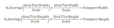
Yes, I also think AutoCAD is supposed to be doing the Math for us, but alas, human intervention is still alive and necessary! Let’s break down the equation…
In this example assume we have created a 1 mile by 1 mile grid and we want the scale to be 300 with a 5% overlap (24in x 24in plot):
1. Viewport Height

2. Viewport Width

The Viewport size will need to be exactly 18.48 x 18.48 inches to plot to scale.
In the next example assume we have created a 6000ft by 4000ft grid and we want the scale to be 500 with a 7% overlap (11in x 17in plot):
1. Viewport Height

2. Viewport Width

The Viewport size will need to be exactly 12.84 x 8.56 inches to plot to scale.
The Process (step by step tutorial)
This link will walk you through the process of setting up a Map Book that will plot true to scale in Map 3D 2009. It makes use of one of the sample Map Book Templates and applies a 6000x4000ft grid, a scale of 500, and a 3% Overlap.
Please give me your feedback so I can make this better!
Jeremiah
Thursday, October 9, 2008
RSS Feed Test
Busy day today! 3 posts now!!!
Testing my RSS Feed... here is the link:
http://feeds.feedburner.com/gisx
Thanks for reading,
Jeremiah
Testing my RSS Feed... here is the link:
http://feeds.feedburner.com/gisx
Thanks for reading,
Jeremiah
FDO makes life easy(er)!
Awesome! Even though I am not around as I should be my Clustr keeps getting larger. Thanks readers!
Now for some content:
FDO is cool. What is FDO? Feature Data Objects. What does it do? Makes our lives easier by allowing GIS Software to connect to non-native data sources natively with read and/or write abilities.
Where can you find it? http://fdo.osgeo.org/
Ill blog more on FDO later...
Jeremiah
Now for some content:
FDO is cool. What is FDO? Feature Data Objects. What does it do? Makes our lives easier by allowing GIS Software to connect to non-native data sources natively with read and/or write abilities.
Where can you find it? http://fdo.osgeo.org/
Ill blog more on FDO later...
Jeremiah
1° of Separation - FDO
What is FDO? And why only one degree?
From http://fdo.osgeo.org/:
FDO Data Access Technology is an API for manipulating, defining and analyzing geospatial information regardless of where it is stored. FDO uses a provider-based model for supporting a variety of geospatial data sources, where each provider typically supports a particular data format or data store. FDO (“Feature Data Object”) is free, open source software licensed under the LGPL.
In a nutshell, FDO allows technologies to access geospatial and non-geospatial data sources in their native format. It is an open source technology that anyone can add to their spatial toolset. right now MapGuide Open Source, Autodesk Map 3D 2008, Autodesk MapGuide Enterprise are tools that leverage FDO.
FDO is XML based and every connection type is called a "Provider" any technology that makes use of FDO can use any of the Providers. New providers appear when someone in the community has a need and solves it with FDO, anyone with the same need can go get that provider from http://fdo.osgo.org/ and be on their way! FDO is fully documented and their are dozens of Open Source Providers and several Paid Providers (like for Smallworld).
Check it out!
Jeremiah
Tuesday, August 19, 2008
Hello all,
What is new and cool???? FDO (http://fdo.osgeo.org/) Providers for Microsoft SQL Server 2008 Spatial, GE Smallworld, and Google KML!
SQL Server 2008 and GE Smallworld from Autodesk:
http://usa.autodesk.com/adsk/servlet/item?siteID=123112&id=11614795
Check Neal's review on KML: http://cadngis.blogspot.com/2008/08/free-fdo-provider-for-kml.html
Opensource SQL Server 2008 and KML from SL-King:
http://www.sl-king.com/
SQL Server 2008 and other FDO providers:
http://fdo.osgeo.org/
See you soon!
Monday, March 24, 2008
Dots from around the Globe!!!
Hello all,
Yes, i am a typical blogger... just shy of two months is not too long of a delay eh?
On to the topic, as you can see in the map to the right I am tracking you (and no, I dont have a personal fleet of little black helecoptors). Cool utility called ClustrMaps, and yes, its FREE. Just sign up, copy the html, paste it into your website or blog and bingo, you've got a real CLUSTER on your hands!!!
Jeremiah
Monday, February 4, 2008
Now Introducing...
Good Day,
Now I guess i should introduce myself. My name is Jeremiah McKnelly. I have been involved in GIS for almost 10 years, being introduced to the geospatial world by my boss asking me to do a little mapping project... and it has been great fun since then! Over the last 10 years GIS has evolved from really cool, very misunderstood techno stuff to a necessary part of life that affects everyone wether they know it or not! Thanks to the evening news maps and the web (especially Google) we are fast becoming a 100% spacially aware society and world. I am very excited about GIS and the new frontiers we overcome daily, and that my friend is why you are reading this blog!
Now in all fairness I must admit GIS does pay my paycheck and I am an employee of the worlds largest Design Software company: Autodesk (the folks that make AutoCAD). AutoCAD and GIS? Yes! We are a Spatially aware company and have been for some time. So as this blog goes on you will see hints of Autodesk on a regular basis, but as my first post states I believe GIS is not limited by anyting but our imaginations and I will stick to that premise!
Jeremiah
Subscribe to:
Posts (Atom)